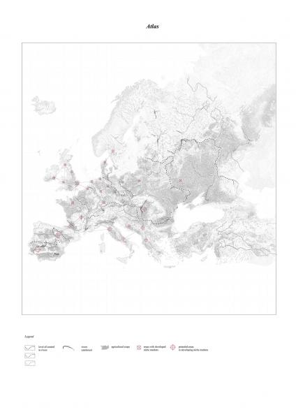
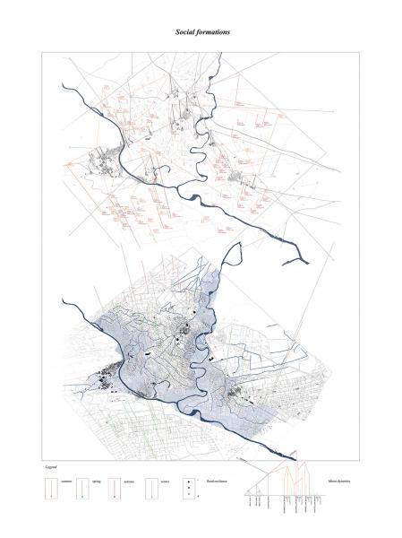
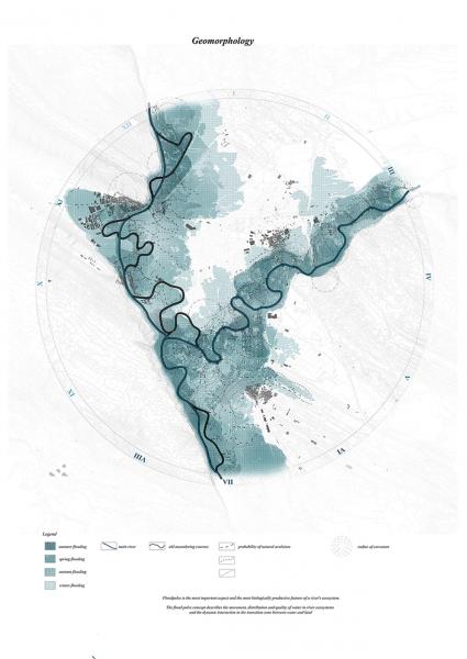
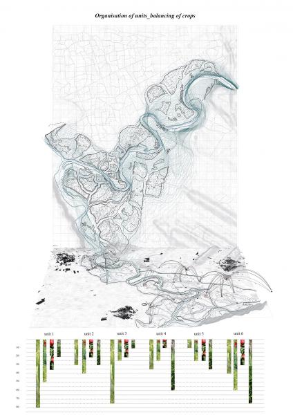
LANDSCAPE-URBANISM
SELECT * FROM students_images2 WHERE student_id = 2079 AND is_visible = 1 ORDER BY sort_order

Atlas

Globalization, mechanisation of agricultural production, new means of transportation of goods and the ever augmenting desire of human to gain more and more power over the landscape has exhausted the natural resources, thus enhancing the exchanging relationships between territories across Europe and developing countries. The atlas tries to map these tendencies motivated from the failure or disability of a territory to be self sufficient.

Territorial formations

The map depicts the conflicts produced by the polemic existing between mechanized agriculture in the floodplain of Navarre and the small scale traditional farming activity, situation existing due to a huge canal construction project in the area.

Floodpulse

The flood pulse concept describes the movement, distribution and quality of water in river ecosystems and the dynamic interaction in the transition zone between water and land.

Anastomosis Avulsion processes

Anostomosis is the condition where the fluvial pattern is defined by the constant abandonment of a course to continue to another, forming a pattern of multiple channels throughout a floodplain.

Social formations

It is crucial to understand and estimate the parameter of human interaction within the territory. Informal work around seasons withing the industrial and agricultural fields indicate the current exhausting of the productive lands, increasing the needs for mechanised water. The negotiation between geomorphological and social parameters give hints for the strategy.

Canal project implications

The multiple implications concerning this strategic and highly questionable activity consist subject of conflict between the small scale, traditional farmers and the large industrial corporations. Economical and environmental assesments indicate strong faults in the ampliation of the first phase of this construction, clearly demonstrating the beneficial model created towards the large scale producers. Environmental disaster, shift from variation of crops to monoculture, disproportional profits compared to the equipment cost nd lack of quality production, are only few of the consequences of the canal.

Avulsion rules

By exploring the alternatives of hard engineering and often destructive interventions on fluvial landscapes, we started studying and examining other emerging approaches, focusing on the enhancement of the natural potentials of rivers. By running simulations over the tendencies of the river, we extract rules in order o build the tool to provoke the avulsions.

Seasonal avulsions

Respecting the rivers season cycle, we design according to the differentiation in patterns and dynamics in timecycles. We run simulations for winter, spring, summer and autumn to establish a solid idea of the behaviour of the river.

Geomorphology

The geomorphological scenario performs as an outcome of a variety of factors: the examination of the possibility of avulsions of the rivers Arga and Aragon through a time cycle of three years, taking into account different flooding conditions and merging them with the actual form of the landscape qualities; slope, programmatic uses, urban settlements. Experimenting with simulations, we investigated the river dynamics that are unveiled if we reconnect the main river with its old courses. By identifying the territorial possibilities for anostomosis, we can form the basis for the implementation of techniques, in order to reassure their maximum integration.

Strategy

The strategy we implement is by instrumenting different methods, cut and fill, reservoirs, inflatable weirs, consolidate in time certain avulsions and proceed with the road infrastructure. We thus develop a fluid strategy in time, widening the flood plain and rearranging the current topography

Timing avulsions-generation

Steps of triggering and actualising the avulsions in time.

Timing topography

Organisation of units

Organisation of the new topography, raised in levels respecting the seasons of flood, distributing the different crops around time cycle and water resilience. We thus balance the current problematic co existing of large plots and uneven labour in time, proposing a territorial rearrengement.

Cartogenesis

The cartogenesis describes the attempt for power redistribution among a reorganised , productive territory. By keeping the problematic consequences of the canal project out of the floodplain, the main design focuses on the idea of fragmentation of space into smaller islands, which will respond in a different set of rules designed to profit the small scale farmers. Cartogenesis forms a critique to the intensive industrialised agricultural lands.

Unit formation

Focusing on a single from the six clusters generated from the cartogenesis, we develop a catalogue of techniques of intervention, being tested in a smaller scale.

Unit scale

Organisation of roads, irrigation and connection bridges in between highest points of different islands in the cluster. Also redistribution of plots and crops according to water needs and resilience, into the islands.

Manufactured grounds

Focusing on a single island, we design the levels of a particular island.Its heights respond to the seasonal floods and provide irrigation needed according to types of crops. urban programmign and processing centers are also allocated in the heigest points of the topography

Simulation video

Natural avulsions simulations_winter season

Simulation video

Natural avulsions simulations_summer season