LANDSCAPE-URBANISM

The location of project is focused on the Iron Gate Dam of Danube River Basin, and our proposal uses their inherent reiverbed sedimentation as a land reclamation mechanism that orchestrates social and cultural formations in these ever-changing territorial landscapes and figure out the strategies towards issues after man-made intervention of dam and simulate what will happen on both the river and cities nearby.

SELECT * FROM students_images2 WHERE student_id = 2081 AND is_visible = 1 ORDER BY sort_order

01-EUROPEAN ATLAS

01-EUROPEAN ATLAS
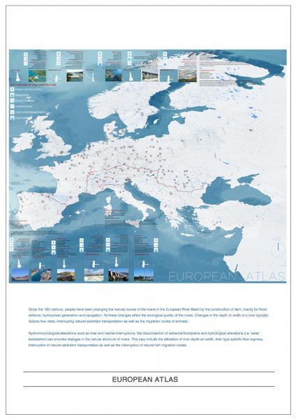
Since the 16th century, people have been changing the natural course of the rivers in the European River Basin by the construction of dam, mainly for flood defence, hydropower generation and navigation. All these changes affect the ecological quality of the rivers. Changes in the depth or width of a river typically reduce flow rates, interrupting natural sediment transportation as well as the migration routes of animals.

02-TEREITORIAL FORMATION

02-TEREITORIAL FORMATION
Hydromorphological alterations on Danube River such as river and habitat interruptions, the disconnection of wetlands/floodplains and hydrological alterations (i.e. water abstraction) can provoke changes in the natural structure of rivers. This may include the alteration of river depth an width, river type specific flow regimes, interruption of natural sediment transportation as well as the interruption of natural fish migration routes.

03-DANUBE RIVER ATLAS

03-DANUBE RIVER ATLAS
The location of project is focused on the Danube River Basin and figure out the issue after man-made intervention of dam and simulate what will happen on both the river and cities nearby after the removal of the dam.
The largest hydropower dam and reservoir system along the entire Danube is located at the 117-km-long Djerdap (Iron Gate Dam I and II) Gorge.

04-SOCIAL FORMATION

04-SOCIAL FORMATION
Iron gate Dams are a significant factor in reducing the amount of Phosphorous from countries upstream the dams, in the Danube River that eventually reaches the Black Sea. The reason for this is that large amounts of sediment - containing P attached to the sediment particles -settle out in the reservoir behind the dams. Although this P is at present stored in the Iron Gates reservoir it may in future be a significant source of pollution in the case of flood events causing chemical P release. This P release and eventual mobilisation could be a pressure factor for the downstream countries but also for the impoundment section upstream of the Iron Gate Dams.

05-GEOMORPHOLOGY

05-GEOMORPHOLOGY
IN-SITU CAP OF LIGHT POLLUTED SEDIMENT
Dredging is very common throughout the DRB. The extraction of sediment is mostly related to navigation (minimum water depth); flood protection purposes; reservoir management

06-CARTOGENESIS

06-CARTOGENESIS
IN-SITU DREDGEING/ EXTRCATION OF MEDIUM + HEAVY POLLUTED SEDIMENT


07-TECTONIC INTERSECTIONS

07-TECTONIC INTERSECTIONS
OFF-SITE REMEDIATION COMPLEX PLATFORM
DEWATER PHYTOREMEDIATE APPLY ADMIXTURES + HYDROCYCLONE MATERIAL SEPARATION

08-MANUFACTURED GROUNDS

08-MANUFACTURED GROUNDS
The proposed strategies is dealing with 2 following issues after dredging the polluted sediments from Iron Gate Dam riverbed:
1-FLOODING RUNOFF TREATMENT WETLANDS
2- RIVER BANK EROSION CONTROL METHODS