LANDSCAPE-URBANISM

Liam Mouritz, Ting-Fu Chang, Xiabin Hu

This project explores the blurred interface between the land and the sea known as the littoral zone. The very matter from which this condition is constructed is wet sand, or sediment. It is this inconspicuous material from which we begin to envision alternative land reclamation scenarios for the littoral of the Mediterranean Sea, that intersect the geomorphological capacity of sediment with the social formations of the territory.

SELECT * FROM students_images2 WHERE student_id = 1905 AND is_visible = 1 ORDER BY sort_order

Our Sea

The Mediterranean Sea can be imagined as a single entity, a closed system of sediment cycling around, with varying political consequences for the 25 different nations and almost half a billion people that exist along its coast. It is a coastline with a scarcity of sediment supply, in which groynes and other hard interventions are repeatedly used to trap sediment at the expense of downstream supply.

Sand Wars Extract

The documentary Sand Wars describes the global scale sediment redistribution through sand mining and sand trading. It is a process which combines both the more obvious top down forces such as dredging, but perhaps more interestingly, the film documents many cases of illegal sand trading and mining where small scale miners collect sand in small bags, while still having the capacity to transport enormous amounts of sand.

Sediment Atlas of the Mediterranean Sea

At any given moment in time, sediment is moving around the Mediterranean Sea. The Sediment Atlas is an attempt at articulating this process, with the intention of highlighting the territories in which an intervention may be warranted. Following research in to traditional cartographic techniques, we have incorporated them in to our map, in an attempt to foreground and represent movement of sediment in the Mediterranean Sea.

CEM Simulations

Our initial tests in the mathematical simulation tool - Coastal Evolution Model (CEM), investigating what kind of landforms can be created through longshore drift and how we might intervene within them.

Territorial Formation - Nile Delta

Following the construction of the Aswan dam in the 1960's, the sediment which typically arrived at the Delta from the Nile River significantly reduced. This has resulted in the steady erosion of the delta coastline, which is occupied by several large lakes, of which Lake Manzala is the biggest. In addition the water from the dam was redirected through a vast system of canals to feed the agricultural production within the delta, whose run-off is eventually directed in to the lakes, in part causing it to fill up.

This process of the lake filling up is accelerated by the fish farming industry which has emerged within the last 30 years as part of the need to feed a rapidly growing population within a country that has a shortage of arable land.

Online Atlas

We think sediment transport can be something negotiated at the Mediterranean scale. With every sediment extraction and accumulation there will be political consequences.
Here someone in the Mediterranean can input a point in the online map, noting how much sediment, the name of the place and the map would draw lines representing sediment flow within that littoral cell, indicating the political ramifications of that sediment action.

Geomorphology - Lake Manzala

The Geomorphology panel describes how sediment arrives as waste run-off from agriculture, through a system of canals, filling up the lake over time, and how it is deposited from the river mouth providing a source of sediment along the coast.

Social Formation - Lake Manzala

The territory of Lake Manzala is occupied by many different groups of people with different interests. This ranges from the surrounding cities and villages, Port Said, El Matereya and Damietta, to the intensive fish farms which occupy the lakes edge and the illegal fish farmers within the lake. This map intents to describe the flows of inputs and outputs within the territory from all these different groups.

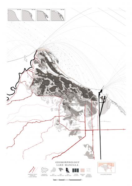
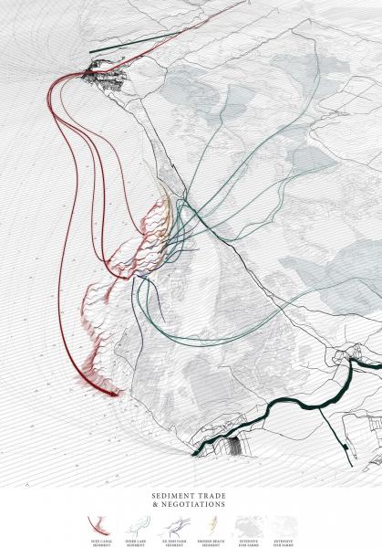
Sediment trade and Negotiations

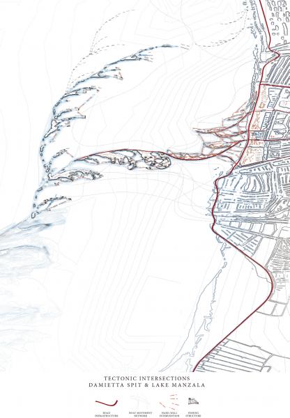
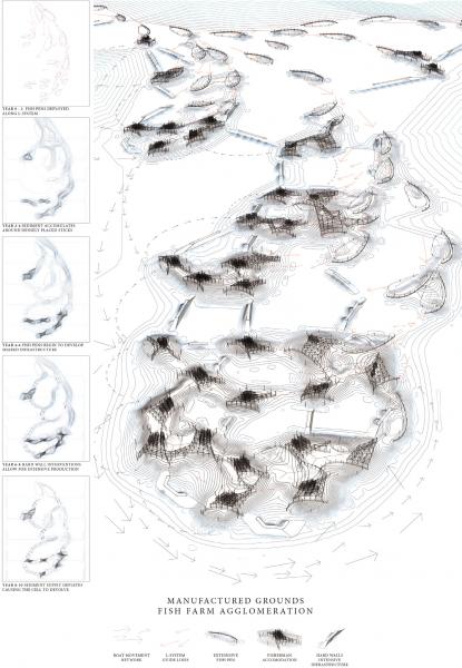
Having identified this global process of sediment shifting around the world, and also in the Mediterranean, we have formulated a strategy for sediment distribution at the scale of Lake Manzala.
Our proposal is perhaps one scenario of how the different groups might negotiate with each other to provoke the coastal spit as an engine for sediment movement from which to expand the existing fish farming industry.
This is part of a general transitioning of the industry within the Lake, moving away from the polluted waters of the interior towards the cleaner brackish water of the spit.
The initiator for this spit reclamation might be the sediment dredged from the Suez Canal, which the government would deposit at the base of the spit with the intention of creating a cheap source of coastal defence to protect the fish farming industry which exists there.
In addition we recognize the conflicted relationship between the local government and the illegal fish farmers in the lake interior, and we are suggesting that those groups could move their extensive stick and net infrastructure in to the oncoming spit as a way of guiding and controlling its formation over time.
This would be complimented by the other mixing of different supplies of sediment, from eroded beaches, and other farmers who wish to migrate towards to coast and bring with them their sediment.
We see this as a negotiation between the interests of the top down government with that of the emergent qualities of the small scale farmers.

L-System Catalogue

This Catalogue describes the various parameters around how we might begin to control the spit.
This intends to combine both the "natural" forces with the existing social condition that exists along the coastline.
For example the spit may begin to intensify, with greater subdivisions as it approaches an existing village. As it connects with this village, the intensive materials would then bleed in to the spit environment. This may result in the intermingling of these different systems of extensive and intensive aquaculture.

L-System Simulations

Tests applying the L-system variations in to the Coastal Evolution Model, to see how sediment might interact with it.

Cartogenesis - Spit Generations

The Cartogenesis intersects what we have discovered in the Social Formations drawing with the Geomorphological situation of sediment to envision an alternative model of land reclamation.
Our proposal considers the spit as part of a shifting plan, in which a skeleton of infrastructural elements would be deployed along the coastline, which catch sediment. When sediment supply is greater - the fish farming industry will intensify and the land will thicken, meanwhile when sediment supply reduces the fish farms will devolve and contract.

Spit Generations

Video of Cartogenesis over time

Tectonic Intersections

This drawing describes the convergence of the extensive fish farms meeting with the intensive fish farms on the land.
The structure would evolve from the initial deployment of some stick and net fish pens and begin to catch sediment forming new ground. Over time the structures will agglomerate in to small fishing villages.

Tectonic Intersections Video

Manufactured Grounds

A modular system of stick and net infrastructure may begin to agglomerate and catch sediment over time, connecting together and forming the ground from which small village clusters will begin to evolve.

Manufactured Grounds Video